Suitable for the creation, application, and management of various types of geological maps in petroleum exploration and development processes.

Petroleum Mapping System
Suitable for the creation, application, and management of various types of geological maps in petroleum exploration and development processes.
GeoMap is a professional mapping tool designed specifically for the petroleum exploration and development industry. It supports the entire workflow of creating, applying, and managing various types of geological maps. Built on robust and standardized digital mapping and graphics editing capabilities, it enables the generation of a wide range of professional maps, including plan maps, contour maps, single-well histograms, well correlation profiles, statistical analysis charts, and development performance curves.
It supports the entire process from rapid data-driven mapping to detailed manual editing and comes equipped with an extensive library of industry-standard symbols and templates, ensuring that all output is both professional in quality and visually refined.
Professionals across disciplines, including geology, geophysics, and petrophysics, rely on disparate software applications to generate maps, cross‑sections, histograms, and similar deliverables. This leads to poor interoperability of data and graphics, hindering seamless collaboration on a unified platform.
The absence of an integrated, efficient toolset impedes the rapid and accurate conversion of exploration and development data, such as well locations, stratigraphic layers, and log curves, into professional, industry‑compliant graphical outputs. Substantial manual intervention remains necessary, resulting in significant time and effort expenditure.
Variations in the application of graphical styles, layout formats, and symbolic conventions across individuals or teams contribute to inconsistent quality in map aesthetics and technical compliance. Such discrepancies undermine both the reliability of outputs and the clarity of technical communication.
A unified underlying graphics engine supports a wide range of professional geological diagrams, including plan maps, cross‑sections, histograms, and contour maps. Employing a plug‑and‑play module design, the technical architecture ensures high integration and scalability.
Equipped with powerful and precise underlying graphics editing capabilities and high‑accuracy rendering technology, the system produces result maps that strictly comply with industry standards while achieving publication‑ready visual quality.
Built on in‑depth oilfield expertise, the system incorporates a specialized algorithm library closely aligned with operational scenarios—including intelligent contour tracking, well trajectory design and calculation, reservoir parameter spatial interpolation, fault auto‑recognition, and sedimentary facies prediction. This ensures that visualization outputs are not merely "drawn" but "calculated," delivering graphics such as structural maps, reservoir property models, and drilling trajectory maps that are both aesthetically refined and geologically accurate, effectively combining domain expertise with computational power.
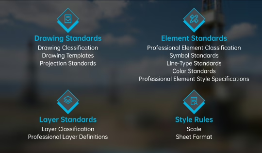
GeoMap emphasizes standardized mapping as its core requirement. By rigorously adhering to national, industrial, and enterprise standards, the platform professionally integrates standardization schemes and embeds extensive map templates, regulations, and specifications. Standards and norms are seamlessly incorporated into the output process through automated or manual application, ensuring that all resulting maps are compliant, visually consistent, and aligned with industrial‑grade mapping requirements.
Empowering Intelligent Energy Through Technology Innovation
Quick Links
About Us
© 2026 All Rights Reserved.